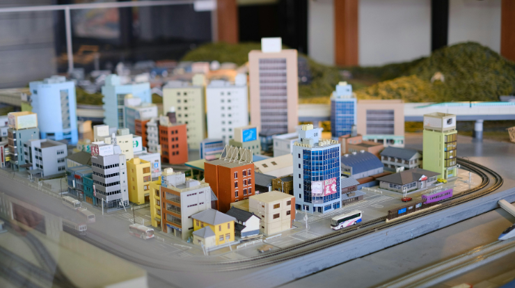
Sightlines and view corridors play a critical role in Dubai’s urban planning and architectural approvals. The city’s skyline, waterfronts, landmarks, and public spaces rely on carefully protected visual connections.
From iconic towers to coastal views, preserving what people can see from streets, buildings, and open areas is a key planning requirement. Physical representations help planners and authorities understand these visual relationships clearly. In this context, model making provides a practical way to study how buildings interact with views across complex urban environments.
Understanding Visual Relationships in Three Dimensions
Sightlines are inherently three-dimensional. They involve height, distance, and alignment, all of which are difficult to judge accurately through two-dimensional drawings alone. Physical models allow planners to observe how buildings rise and overlap within a real spatial context.
By viewing a project from multiple angles, reviewers can assess whether key landmarks remain visible and whether proposed structures interrupt important vistas. This three-dimensional clarity supports more informed decision-making during planning reviews.
Evaluating Landmark Visibility Across Large Sites
Dubai places strong emphasis on maintaining visibility of major landmarks, whether they are cultural icons, waterfront edges, or skyline features. Physical models allow planners to trace lines of sight from public spaces, roads, and surrounding developments. They help determine if a new structure blocks or frames a landmark view. This assessment is especially important for large-scale developments where multiple buildings interact visually over long distances.
Assessing Height Impact on Surrounding Areas
Building height is one of the most influential factors affecting sightlines. Physical models make it easier to compare proposed heights with existing surroundings. Planners can see how taller elements affect lower neighborhoods or public spaces. This helps authorities judge whether height transitions feel balanced or abrupt. In dense areas of Dubai, this evaluation ensures that new developments respect their visual context.
Supporting View Corridor Protection Policies
Dubai’s planning frameworks often define protected view corridors linked to roads, waterfronts, or public spaces. Physical models help visualize these corridors clearly. Reviewers can identify whether proposed buildings intrude into protected visual paths. By physically aligning viewpoints with the model, authorities gain confidence that planning guidelines are being respected. Through model making Dubai, compliance with view corridor regulations becomes easier to verify.
Improving Communication During Approval Meetings
Discussions about sightlines can become technical and subjective when relying only on drawings. Physical models provide a shared reference that simplifies these conversations. Stakeholders can point to specific locations and discuss visual impact directly. This clarity reduces disagreement and speeds up approvals. In Dubai’s multi-stakeholder planning environment, effective communication is essential.
Testing Design Adjustments and Alternatives
During the approval process, authorities may request changes to building placement or height to protect views. Physical models allow design teams to test these adjustments quickly. Modified elements can be compared side by side to see how changes improve or worsen sightlines. This flexibility supports collaborative problem-solving rather than repeated redesign cycles.
Understanding Street-Level and Pedestrian Views
Sightlines are not only about skyline views. Street-level experience is equally important. Physical models help planners understand what pedestrians will see as they move through streets, plazas, and public spaces. They show how building edges, setbacks, and openings affect visual comfort. This perspective supports more human-centered urban design, which is increasingly valued in Dubai.
Evaluating Cumulative Visual Impact
In large developments, multiple buildings can collectively affect views even if each one complies individually. Physical models allow planners to assess cumulative impact. They show how groups of buildings interact visually and whether they create unintended barriers. This broader assessment is difficult to achieve through isolated digital views. Model making helps authorities consider the overall visual outcome rather than individual components alone.
Supporting Investor and Stakeholder Confidence
Clear visualization of views is important not only for planners but also for investors and developers. Physical models help demonstrate that valuable views are protected or enhanced. This transparency builds confidence in the project’s long-term value. In Dubai’s competitive real estate market, clearly communicated visual quality can influence approval support and investment decisions.
Reducing Risk of Post-Approval Disputes
Poorly evaluated sightlines can lead to disputes after approvals are granted. Physical models help identify issues early. By addressing potential conflicts before construction, planners reduce the risk of objections or redesigns later. This proactive approach saves time and resources for all parties involved.
Complementing Digital View Studies
Digital simulations and view analysis tools are widely used in Dubai. However, physical models complement these tools by offering intuitive understanding. They provide constant visibility without relying on software navigation. This combination allows authorities to balance technical accuracy with spatial intuition during evaluations.
Conclusion
Evaluating sightlines and view corridors is a vital part of Dubai’s planning and approval process. Physical representations bring clarity to complex visual relationships that cannot be fully understood through drawings alone. By supporting landmark visibility, height assessment, regulatory compliance, and effective communication, model making remains a valuable tool in shaping visually balanced and well-approved developments across the city.

![Those Were the Days [v0.002] [YellowFoot Games]](https://mydailyblog.org/wp-content/uploads/2026/06/Those-Were-the-Days-v0.002-YellowFoot-Games.jpg)